They’re done this globally apparently. They just got rid of the provincial park option and defaults all government operated nature reserves, of any government, as “state parks”.
Seems very shortsighted and with a disregard for other countries. Extremely confusing move by google.
yea, ‘state park’, as in ‘operated by the state’
I can see why they did this, but its really stupid, especially at a time like this. i’ve reported half a dozen parks.
There was no reason to do this other than stay out of Trumps retaliation zone. It is wrong to say operated by the state when it is operated by the province.
My theory is that some asshole at google thought it was soo much to keep track of what every government globally calls their government operated parks and nature reserves, and just wanted a blanket term for it and went for “state park”, with no consideration for how itd piss most countries off.
Bullshit. The fact it is happening now is no mistake.
Yep. Trump’s trying to ramp up support for the Canadian Anschluss and there are no more coincidences
I doubt it, its the same issue with google changing Gulf of Mexico to Gulf of America recently. Its a USA thing, all other mapping systems still have it as Gulf of Mexico because they aren’t bowing to trump and elon. A state and a province are not the same, provinces have less autonomy than a state.
All? Sorry Apple is doing the same.
Sorry I meant all other country/regiinal mapping systems, Non USA
oh, thats 100% what happened.
“should we vary what these are called by country?”
“ehh, that would cost like $10,000 of developer time around the globe, just standardize it”
No its the same as the recent Google move of renaming Gulf of Mexico to Gulf of America, it is not easier, it just appeases trumps new mandates. Open Map systems around the world already include terms for Country/State/Province/territory, etc. Its a tag label in a program field.
Pretty sure this change was from November, but it’s an issue now because of the Cheeto
Online articles say people have screenshots from a few days ago as of Provincial and now it says State Park, so even if google did make a back end change before January then the timing is odd for it to be showing changes now.
So where they called provincial parks before?
Some were, some weren’t. This goes back almost to the beginning of Google Maps, but seems they’ve started to standardize them recently. They claim they started before Trump’s inauguration.
Yep. Its not technically wrong to call them state parks, but still fuck’em that is our PROVINCIAL park.
Maybe a small cultural hill we are on right now but we give us enough of these hills and suddenly we lose any semblance of cultural uniqueness.
It is wrong as the state would be national government. So these parks are run by the provinces and not the state of Canada.
Oh, 100% agree.
I’m just saying I understand WHAT they were trying to do, even if it stepped on a cultural landmine. As I said, Ive reported about a dozen parks now myself.
The problem is that for us there is a big difference between municipally run, province-run, and federally run parks. We also have private parks, privately owned but publically accessible parks, and of course, amusement parks.
half a dozen
Fucking Casual. :-P
I fully expect they’re gonna close my google account based on the amount of work some poor underpaid kid now has to do. I think I got every park in my province - already a herculean feat - and the one next door. It’s a lotta parks. I’m a little crazy.
ooh, hope you did BC too
I keep adding to it, a couple here, a couple there.
You are doing great patriotic work, I wish I had the drive to do that. Instead I am writing daily letters to the MLAs and premier of Saskatchewan. And cancelling services offered by US companies.
For me, using English (GB) as localization, they appear as national parks. Maybe it’s the term they use for English (US) set phones 🤔 Im located in Finland as well so.
Even the ones in US show up as national for me. Also checked the gulf of mexico, it’s still that for me.
That would make sense if we used English (US), but we use English (CA). Just a brief check of the parks in my area shows all the national parks are labeled “National Park”, the provincial parks are almost all “State Park[s]” with the occasional “Park”, and the regional parks have no consistent or logical pattern but I counted at least 5 different park labels.
Canada really needs to develop its technology to get off of oppressive American tech. We need to work with other countries and develop our own tech to combat this. Absolutely insulting. Just a little “oopsie” after over a decade of not having mislabelled parks? The stink is showing.
Open source options exist. We just need more people using OpenStreetMaps and shit.
A government funded utility that utilizes regional GIS and aerial mapping would go a long way. Google’s got the upper hand on directions and traffic reporting though, so that would take more time to make effective. A lot of that is genuinely due to the number of users that exist on the platform though. I think if you tried to implement similar location data analysis for government infrastructure, people would be up in arms at the idea, despite being perfectly happy to provide the same data to Google.
It’s unfortunate that Google is as prevalent a default service as they are, but it’s hard to ignore how good a service they offer, and how long the development period has been to get them there.
Yeah people have to start using OpenMaps more, and OSMAnd app alternative for navigation
The geodata and related open source technology to edit, review, and host it is already available from openstreetmap community
We have. Only it’s not well known, because of Google’s monopoly.
Then let’s start naming them and putting them out there. If they’re just maps but we need guis for apps on these, then it’s a great time to start that process and get developers in on it, preferably open sourced if possible.
My guess is there would be lots of developers willing to work on a project like this to help distance us from America.
Every canadian should switch to Organic Maps for national security purposes.
Does that matter if your os is still Android (like most people are)?
It will prompt you to use Google’s Maps or any other map program you have installed when you clock on an address. You may have to reset the default program for map links if you had more than one option and chose Google Maps as the option in the past, though.
Feels like we’re being politically raped, and it’s really pissing me off.
Yeah, they elected a rapist so…
Ikr?! How do you even begin to make sense of that?! You can’t! And now, here the rest of us are being forced to deal with it. Makes me wanna scream.
Please do: loudly and at the local US consulate of possible. If not, if there is a town hall, they need to hear your complaint.
If people are wondering why Google is simping to Trump, they have been convicted of being a monopoly and the antitrust action is now in the penalty phase.
The action started under Trump I, was vigorously pursued by Biden’s Lena Kahn and the conviction secured. Now all that’s left is to decide the penalty, which could range from a strongly written letter to a breakup of the company.
It is really to bad Canada is not going after them yet.
I’m getting Microsoft, Clinton & Bush vibes here…
from “Not Evil” to “Prime Evil” in just a couple decades.
decades
Years
They’ve ramped it up in recent years, sure, but I think they been dormantly evil since they came on the scene and we just didn’t realize it until the hooks were in deep.
Perfect strategy for this kinda thing, and now they can just be brazen about it. Kinda like a certain red party in a certain shithole country.
I mean I knew Americans weren’t great at geography, I didn’t realize it was this bad.
I’m not seeing this at all.
Provincial Parks in BC are all still called ‘xyz provincial park’.
If you explicitly search for ‘state park’ all the provincial ones come up, but there’s nothing in any of their details mentioning ‘state’ in anyway.
/edit: found it.
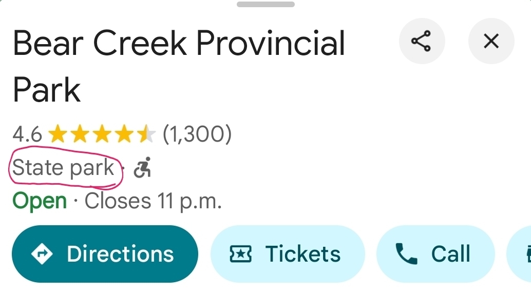
It’s subtle, but it’s there.
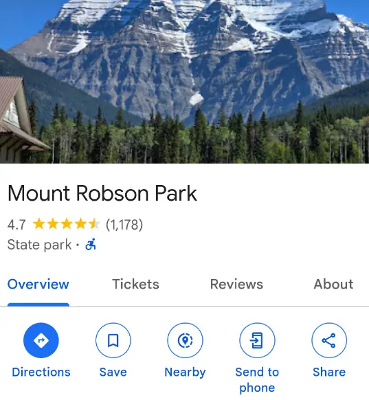
Mount Robson Park from both search and maps:
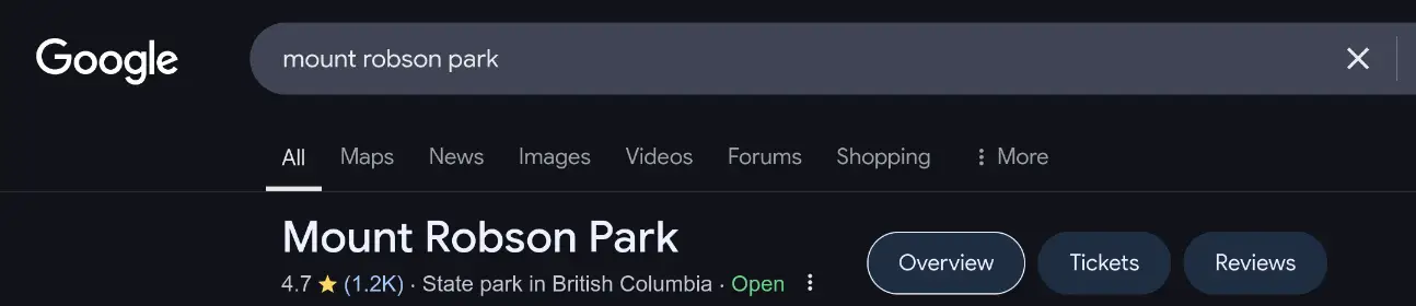
They don’t let you specify in the ‘edit suggestion’ what it should be; but they let you add images.
/edit submitted one for every park in BC.
Congrats. It’s a lot of parks.
Looks like they have not changed all of them yet

Just label the US as South/Lesser Canada.
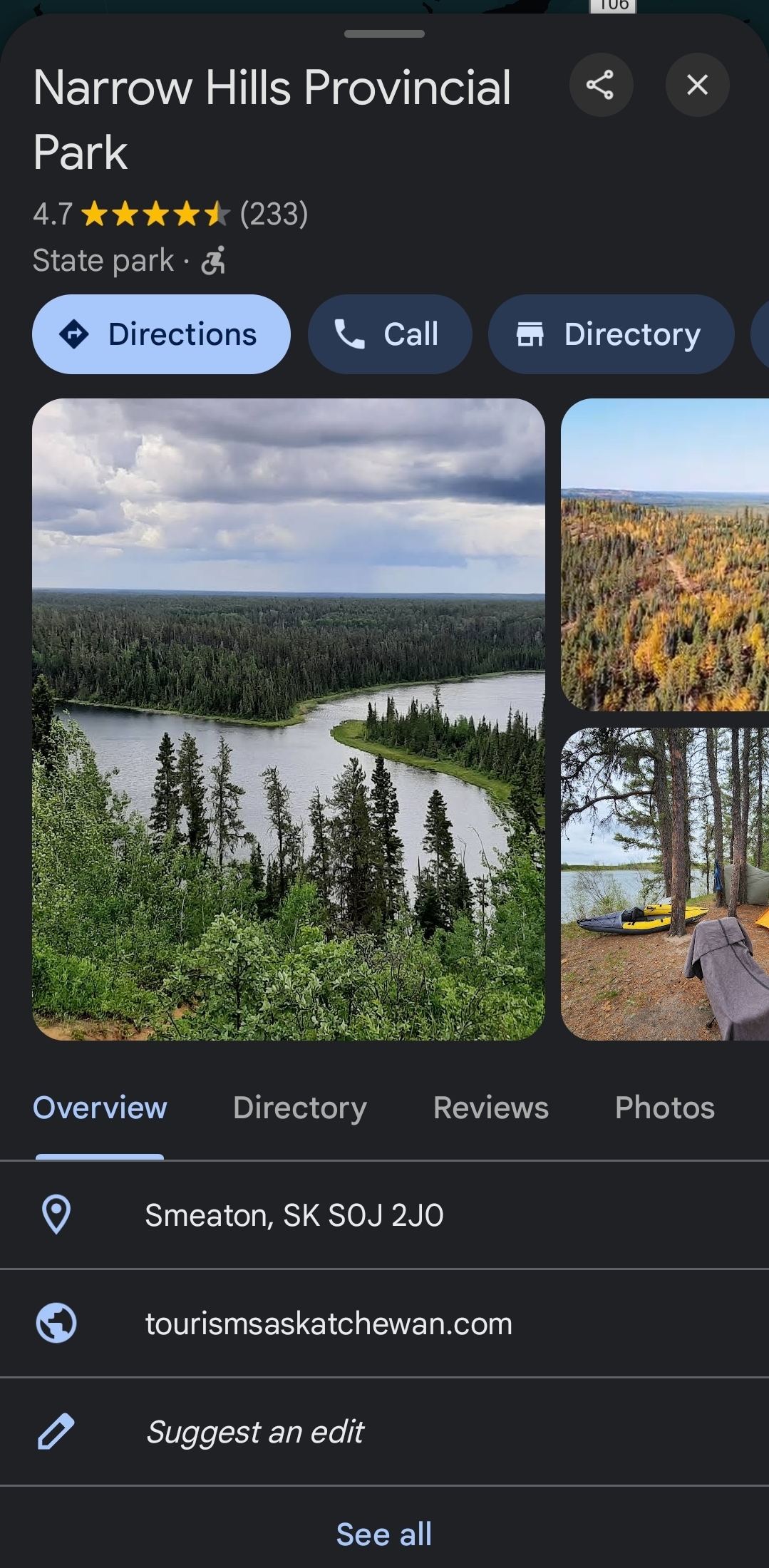
Just checked and sure enough, nearby provincial parks are labelled ‘State Park’
Example:
The app is showing provincial and national for me. I’m in NS and have a few around the city and they aren’t mislabeled from what I see.🤷🏻♂️
Either I’m the odd one out or they changed it back.Edit: found one, how have you been reporting this?
May as well start calling temples “churches” and change all speed limits to Mph since it seems we’re in a “being wrong” contest.
They show up as provincial parks for me?
Some of them are listed as state when you bring up their card.
Came here to talk about this as well.